Research Rules
Maps
NLS Maps
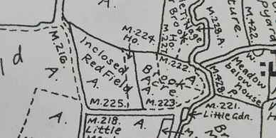
Historical maps are an amazing resource for any historical researcher and detectorist.
The insight it provides regarding land use, previous paths, boundaries and its changing conditions are significant factors to consider before commiting any valuable detecting time to an area. This can include ;
Estate Maps, Tythe maps, Field Maps.
NLS Maps
NLS Maps
National Libary of Scotland (NLS)
This is my personal favourite tool for reserach and in the field review. It is an amazing app that has brought me amazing results. I personally use the
Explore georeferenced maps feature but others like the Side By Side. This allows you to overlay & bleed historic map through current mapping.
https://maps.nls.uk/geo/explore/
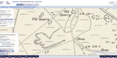
Historic England

Historic England have an amazing archive of aerial images and archaeological resources. They have been extremely busy over the last years compiling this resource into the 2 very significant application that are truely brillant.
Aerial Archaeology Mapping Explorer
https://historicengland.org.uk/research/results/aerial-archaeology-mapping-explorer/
Aerial Photograph EXplorer
https://historicengland.maps.arcgis.com/apps/webappviewer/index.html
Heritage Gateway
Heritage Gateway
The Heritage Gateway is a brilliant method of understand the historical records from your region.
Lidar mapping
Heritage Gateway
Lidar mapping
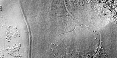
Lidar has expanded the knowledge of Landscapes throughtout the world in a very short space of time. This resource is an amazing visual aid to making determinations about potential sites of interest as well as the discovery of new ones.
The UK has some great coverage as a result of the DEFRA flood and asset managment program.
Quick resources can be accessed via. these sites.
https://houseprices.io/lab/lidar/map
More detailed maps can be accessed directly from The Defra program, but this does require some understanding of digital terrain usege.
https://environment.data.gov.uk/DefraDataDownload/?Mode=survey
GIS Use
Heritage Gateway
Lidar mapping
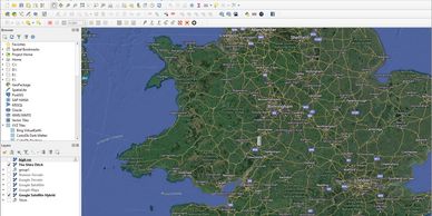
GIS is a must for any person whom is into their historical research and basic map management. Free products like QGIS are very useful for detectorists to manage find locations and research with overlay etc. For the field and landscape archaeologists among us the resource is essential. The mapping of crititail survey data from geophysical to areial is vital to make key interpretations and more.